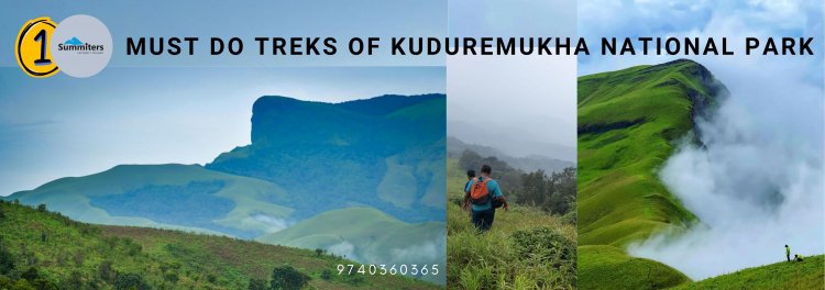
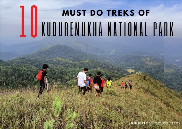
10 Must do treks of Kuduremukha National Park
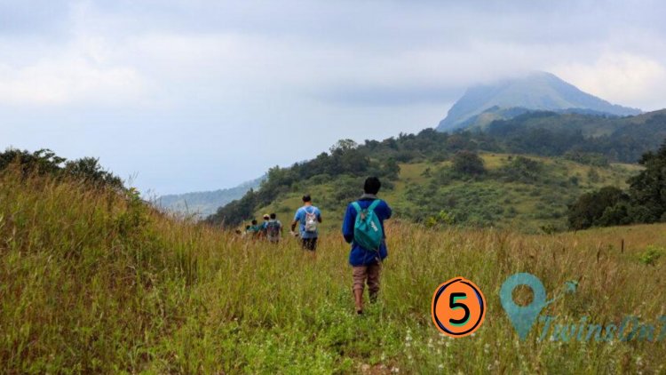
Weekend treks in Chikmagalur are the first choice of any adventure enthusiast. Among them, Kuduremukh is something must do of many, situated in Kuduremukha National Park. Known for scenic beauty, Kuduremukh offers a few more such weekend options for the adventurous. Enchanting meadows of Netravati, Kalasa ridge top trek, Kurunji Kal, Vali Kunja, Gangadi Kal, and a few more. Those who have hiked the green locales and sholas in the Kudremukh region and admired it. It is sure that they will include them in their bucket list for next season for a weekend. Don't be in a hurry. Wait, until every blade of grass turns green!
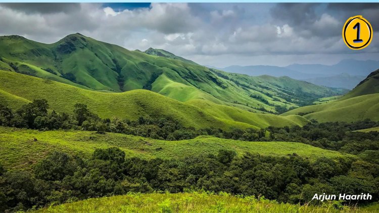
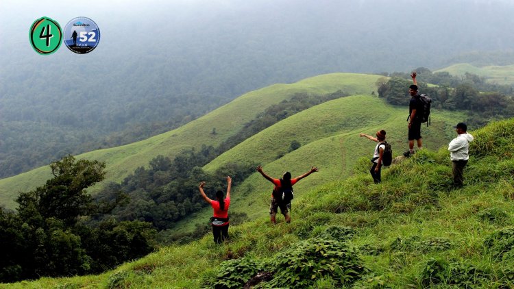
Mention Western Ghats, comes to mind vistas of a thick cover of evergreen forests, winding ghats, perennial streams, grasslands, the origin of rivers, Shola forests, and innumerable cascades that greet us. The high misty-clad mountains teeming with unique flora and fauna are a storehouse of surprises. For nature lovers, researchers, naturalists, photographers, and hikers this is a haven!
Kuduremukha is the name of a mountain range and an individual mountain peak located in Chikmagalur district in Karnataka. It is also the name of a small hill station and iron ore-mining town situated near the mountain, about 20 kilometers from Kalasa in Kalasa Taluk. The name is Kuduremukha literally means "horse-faced" in the local dialect Kannada and refers to a particular picturesque view of a side of the mountain that resembles a horse's face. It was also referred to as 'Samseparvata', historically since it was approached from Samse village. Kuduremukha is Karnataka's 2nd highest peak after Mullayanagiri and the 26th highest peak in the western ghats. The nearest International Airport is at Mangalore which is at a distance of 99 kilometres.
The Kudremukh National Park in the Western Ghats is a part of the world's 38 ‘hottest hotspots’ of biological diversity, a UNESCO World Heritage Site
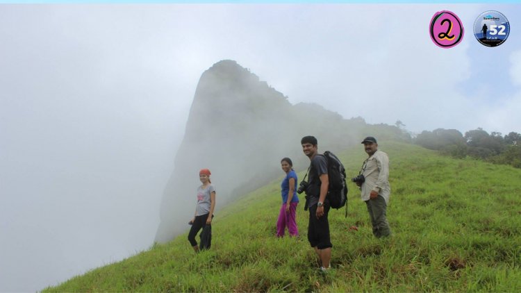
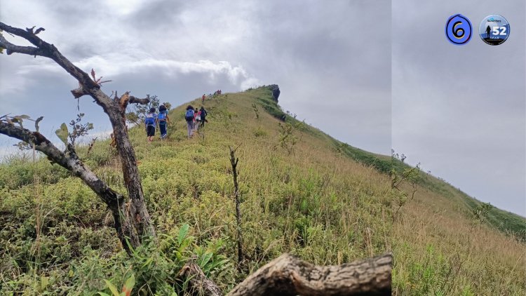
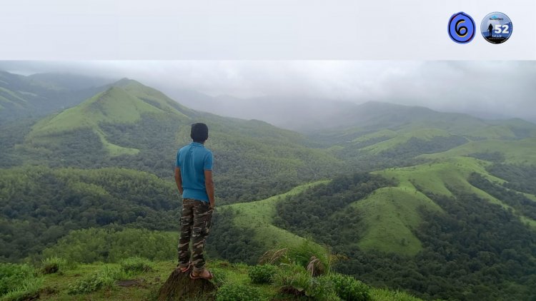
1. Kuduremukha
The trek to Horse Face Peak after a jeep drive from Balagal hamlet on Kutcha road 8km starts from the forest check post of a small village – Mullodi. Located 96km in the district of Chikmagalur. The most popular samse is just 2 km away in a scenic location. It takes an overnight journey of 335km from Bangalore to reach here. The word “Kudremukha” means ” horse face” in local Kannada Language. The name is given to the mountain for its resemblance to the face of a horse. Kudremukh Trek includes a dense forest, a shola forest of trees with water streams flowing on the trail. The Trek is a visual treat for trekkers residents of Mangaluru, Bengaluru, and nature lovers in general. The peak is the third highest peak in Karnataka.
The beauty of Kudremukh Trek is enhanced during monsoon and post-monsoon, The view after a successful summit is a never-ending panorama.
It is a perfect trekking getaway to venture on from Bangalore, which makes it the most advantageous destination for weekend adventure planners.
Few Facts
- Difficulty level: Difficult
- Trek Length: 18 Kms in total (Two way) approx
- Distance from Bangalore: 400 Kms (One Way)
- Minimum Age: 7 Years
- Weather: 21 to 30 Degrees ( June to February)
- Attraction: Beautiful Landscape and grasslands, flora and fauna, Streams and waterfalls
- Stay Options: Homestay and Camping Options @ Samse
- Basecamp: 3 km away
- Washrooms: Only at Base Camp
- Trekking Restrictions: Yes Forest permission is required and Mandatory
- Guide: Mandatory as per forest guidelines @ Ratio 10 :1
2. Kurunji Kallu
At an elevation of 5751 lies a peak named Kurinjal Peak Trek Near Kuduremukh National Park. Experience the trek to the top to bring a new environment where you can encounter pristine nature and peace. Named after the Kurinji flower, a species that blooms once in 12 years on the slopes of the western ghats in Chikmagalur. The tropical forests consist of tiny streams, and verdant meadows, all covered by the trail.
Few Facts
- Difficulty level: Easy to Moderate
- Trek Length: 10 Kms in total (Two way) approx
- Distance from Bangalore: 370 Kms (One Way)
- Minimum Age: 7 Years
- Weather: 21 to 30 Degrees ( June to February)
- Attraction: Beautiful Landscape and grasslands, flora and fauna and Streams
- Flora: Kurunji Flower, Impatiens, Orchids - Seethale
- Fauna: Lion Tailed Macaque, Giant squirrel and Indian Gaur
- Stay Options: Homestay and Camping Options @ Samse
- Basecamp: 3 km away
- Washrooms: Only at Base Camp
- Trekking Restrictions: Yes Forest permission is required and Mandatory
- Guide: Mandatory as per forest guidelines
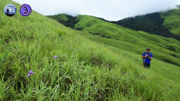
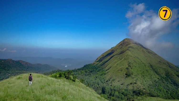
3. Netravathi Peak
A lesser-known trek in the Kudremukh range of western ghats is becoming popular among the trekking fraternity. A bucket list of many. Unlike other peaks, it is not visible until one trudges through the grasslands. A murmuring stream and perennial cascades amuse the visitor. The velvet green slopes with the sight of Indian gaur grazing mesmerizes you during your visit in monsoon. Don't forget to witness the cloud formation on the ridge. Sure you will admire it by heart!
Few Facts
- Difficulty level: Easy to Moderate
- Trek Length: 14 Kms in total (Two way) approx
- Duration: 5 - 6 hours
- Distance from Bangalore: 340 Kms (One Way)
- Minimum Age: 7 Years
- Weather: 21 to 30 Degrees ( June to February)
- Attraction: Beautiful Landscape and grasslands, Waterfalls and Stream
- Stay Options: Homestay and Camping Options @ Samse
- Washrooms: Only at Base Camp
- Trekking Restrictions: Yes Forest permission is required and Mandatory
- Guide: Mandatory as per forest guidelines @ Ration 10 : 1
4. Gangadi Kallu
Seems like an odd name, but Gangadi Kallu or Gangari Kal is located about 20 km from Kudremukh sharing a border. The point where you start is about 9kms from Kudremukh colony. The trail meanders through open grasslands and under a canopy. Where the former route takes you in a jeepable track the later is through thickets of the jungle typical to Western Ghats.
The magnificent cone-shaped rock face cliff derives its name from the Kurinji flower Strobilanthes kunthiana. Neelakurinji.The shrub is found in the shola forests of the Western Ghats in South India. The purplish-blue flowers of Neelakurinji blossom on the slopes gregariously only once in 12 years. As one climbs, you can glimpse the Lakhya Dam backwater and unknown peaks of the Kuduremukh range. The play of light and misty hills makes every step memorable with loads of experiences
Few Facts
- Difficulty level: Moderate
- Trek Length: 12 Kms in total (Two way) approx
- Distance from Bangalore: 370 Kms (One Way)
- Minimum Age: 7 Years
- Weather: 21 to 30 Degrees ( June to February)
- Attraction: Beautiful Landscape and grasslands, flora and fauna.
- Stay Options: Homestay and Camping Options @ Samse
- Basecamp: 10 km away
- Washrooms: Only at Base Camp
- Trekking Restrictions: Yes Forest permission is required and Mandatory
- Guide: Mandatory as per forest guidelines @ Ratio 10 :1
5. Vali Kunja
A very offbeat peak called Valikunja lies about 31 km north of the Kurinjal Peak in the Kudremukh National Park between the Sringeri and South Canara border of the Kudremukh. Valikunja is also called as Ajjikunja. The trek covers a total distance of 15 km both ways. The trek begins with a gradual walk through a canopy of forest. A gradual climb goes further heading into the dense forests and later trudging through beautiful grasslands. The last stretch ends with a 70-degree slope climb on a zig-zag path. One can witness the footprint of King Vali at the peak. The trek not only gives a panorama view of the surrounding villages in Karkala district and the dense Shola forest. Don't be surprised if you encounter bison, sambar, wild boars, or a bear, it is said to be home to endangered species such as lion-tailed macaques and Hornbills too.
Few Facts
- Difficulty level: Easy to Moderate Plus
- Trek Length: 18 Kms in total (Two way) approx
- Distance from Bangalore: 400 Kms (One Way)
- Minimum Age: 7 Years
- Weather: 21 to 32 Degrees ( June to February)
- Attraction: Beautiful Landscape and grasslands, flora and fauna, Stream
- Stay Options: Maavinakome Homestay and Camping Options @ Samse
- Basecamp: 50 km away
- Washrooms: Only at Base Camp / Forest office
- Trekking Restrictions: Yes Forest permission is required and are Mandatory
- Guide: Mandatory as per forest guidelines @ 10 : 1 Ratio
6. Chupi Gudda
Not much is known or spoken about this silent getaway, a chupa rustum, named chupi gudda. It is may be because of a cornice or hood-like ridge running along the peak.A backyard trek more or less for those who would like to laze around. A scenic bumpy jeep ride and walk traversing a slope can be a respite for those who want an easy one. The view of Kudruremukha Peak from here is breathtaking!
Few Facts
- Difficulty level: Moderate
- Trek Length: 12 Kms in total (Two way) approx
- Distance from Bangalore: 370 Kms (One Way)
- Minimum Age: 7 Years
- Weather: 21 to 30 Degrees ( June to February)
- Attraction: Beautiful Landscape and grasslands, flora and fauna.
- Stay Options: Homestay and Camping Options @ Samse
- Basecamp: 10 km away
- Washrooms: Only at Base Camp
- Trekking Restrictions: Yes Forest permission is required and Mandatory
- Guide: Mandatory as per forest guidelines
7. Kalasa Ridge Traverse
It is also known as Meruthi gudda.One of Kalasa's most stunning yet unspoiled trekking trails on the fringes of National Park. Imagine taking your initial steps into your trek at the foothills of Kalasa village, Karnataka, in the lap of mountains and nearby peaks and gushing waterfalls, all within a radius of barely 10 km.
Few Facts
- Difficulty level: Moderate
- Trek Length: 12 Kms in total (Two way) approx
- Distance from Bangalore: 350 Kms (One Way)
- Minimum Age: 7 Years
- Weather: 21 to 30 Degrees ( June to February)
- Attraction: Beautiful Landscape and grasslands, flora and fauna.
- Stay Options: Homestay and Camping Options @ Samse
- Basecamp: 13 km away
- Washrooms: Only at Base Camp
- Trekking Restrictions: Yes Forest permission is required and Mandatory
- Guide: Mandatory as per forest guidelines @ 10 :1 Ratio
8. Kalsanka
The fringes of Kuduremukh Peak, are dotted with myriad pinnacles with explicit views. If you have dreamed in a day, then if you crave to visit those in reality. Then you are sure you don't make promises, But realize them, by being on top of it. You might ask, what's in the name..?.
- Difficulty level: Moderate
- Trek Length: 12 Kms in total (Two way) approx
- Distance from Bangalore: 350 Kms (One Way)
- Minimum Age: 7 Years
- Weather: 21 to 30 Degrees ( June to February)
- Attraction: Beautiful Landscape and grasslands, flora and fauna.
- Stay Options: Homestay and Camping Options @ Samse
- Basecamp: 12 km away
- Washrooms: Only at Base Camp
- Trekking Restrictions: Yes Forest permission is required and Mandatory
- Guide: Mandatory as per forest guidelines @ 10: 1 Ratio
9. Attiberi
in reality, the pictures in postcards don't do justice to the place. Such is the beauty !. Rolling hills, velvet-laden grasslands, and wind songs for company.Untouched by human intervention, the hills commune!
The streams flow in rhapsody and grasslands motivate us to climb high and decipher what lies in the far horizon ?. Did some ask where it is. ?. Yes its sure tucked away snugly in Western ghats. Where else !!! IN the bosom of Western Ghats
Few Facts
- Difficulty level: Moderate
- Trek Length: 12 Kms in total (Two way) approx
- Distance from Bangalore: 370 Kms (One Way)
- Minimum Age: 7 Years
- Weather: 21 to 30 Degrees ( June to February)
- Attraction: Beautiful Landscape and grasslands, flora and fauna.
- Stay Options: Homestay and Camping Options @ Samse
- Basecamp: 10 km away
- Washrooms: Only at Base Camp
- Trekking Restrictions: Yes Forest permission is required and Mandatory
- Guide: Mandatory as per forest guidelines @ 10 : 1 Ratio
10.Maanikya Gudda
Few Facts
- Difficulty level: Easy to Moderate
- Trek Length: 12 Kms in total (Two way) approx
- Distance from Bangalore: 400 Kms (One Way)
- Minimum Age: 7 Years
- Weather: 21 to 32 Degrees ( June to February)
- Attraction: Beautiful Landscape and grasslands, flora and fauna, Stream
- Stay Options: Homestay and Camping Options @ Samse
- Basecamp: 50 km away
- Washrooms: Only at Base Camp
- Trekking Restrictions: Yes Forest permission is required and Mandatory
- Guide: Mandatory as per forest guidelines @ 10: 1 Ratio
We Summiters Adventures driven by obsession have made an honest attempt and recommending you from the bottom of the heart the 10 BEST hikes of Kuduremukha National Park.If you been to Kudremukh Peak and admired it.Then sure you will recommend it to others to explore.
Make sure during exploration to respect our ecosystem. These places are not places to rejoice and pollute. They are the lifeline of the planet. We have ONE Save it!
Please be free to call us + 91 9740360365 / Msg us on Whataspp