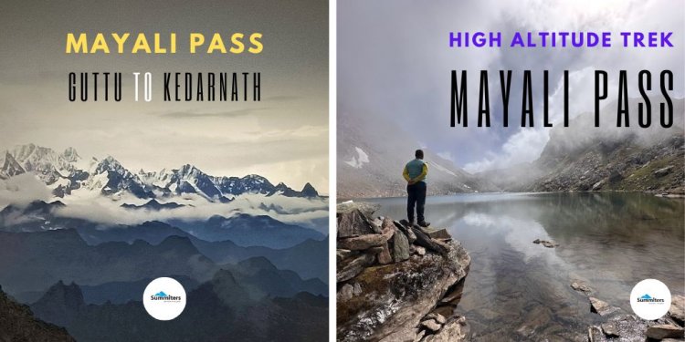
Mayali Pass Trek - A Journey across high altitude lakes to Kedarnath
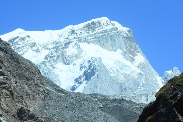
High-altitude Treks across, the Gharwal Himalayas have always been on the bucket list of many adventure enthusiasts. A suitable group, attitude, preparation, decisions, team, weather, guide, safety measures, crisis management, and grace of God are the factors that influence and lead to the success of every adventure pursuit. A High Altitude Trek Mayali Pass located at 17,300 feet is one such pass and a bucket list of many trekkers. Mayali Pass offers a distinctive landscape such as forest, river flora - fauna, waterfalls, snow, and high-altitude pristine lakes that greet you. Indeed a mixture of adventure and pilgrimage.

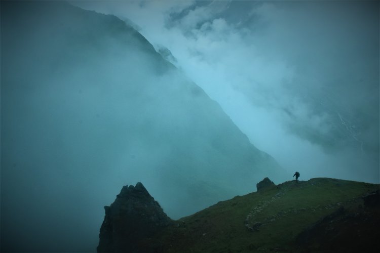
The thick veil of mist lifted and my curiosity doubled. I could hear the sound of the temple bells, in tune with the roaring sound of river Mandakini down in the valley.
I was descending the steep cliff from Vasuki top towards Kedar Valley, culminating at the abode of Lord Shiva - - Kedarnath
Day 02 Start from Guttu Village Altitude 1578 m
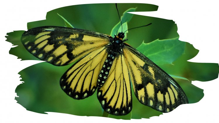
Our Journey started a week back from Guttu, a sleepy hamlet in the Bhilangana Valley. The sighting of the Monarch butterfly inspired us, a sign of good luck and reminding us that we are heading in the right direction with the right people.
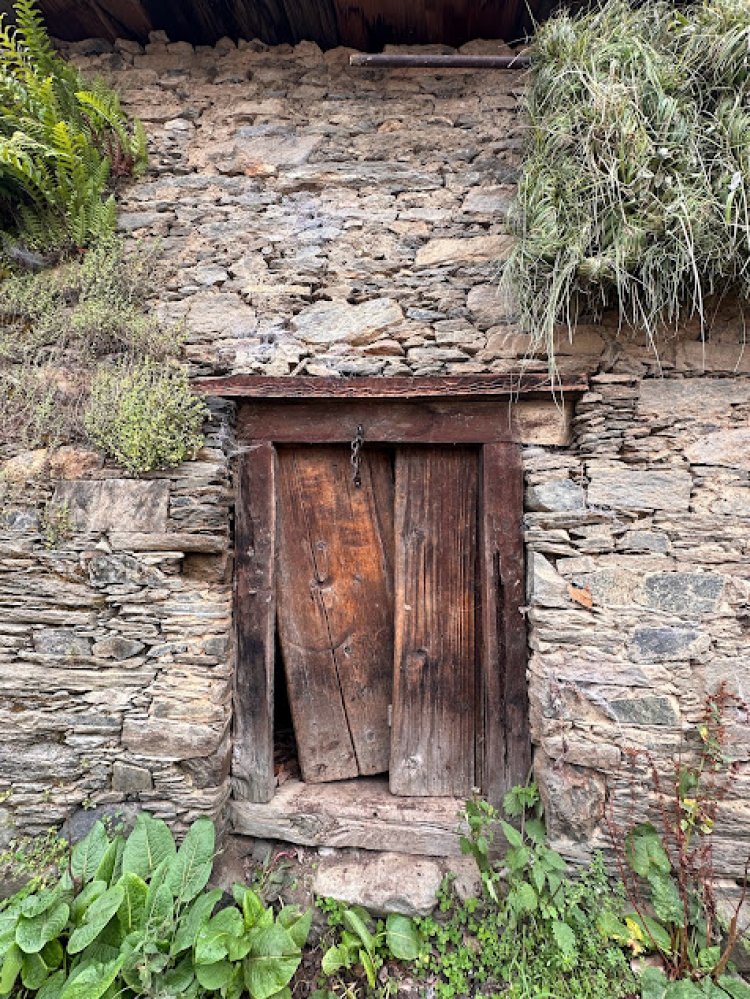
A bumpy ride of 12 km brought us to the last road headed to yet another village called Gangi located at an Altitude of 3100 m with architecture unmatched.
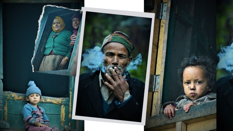
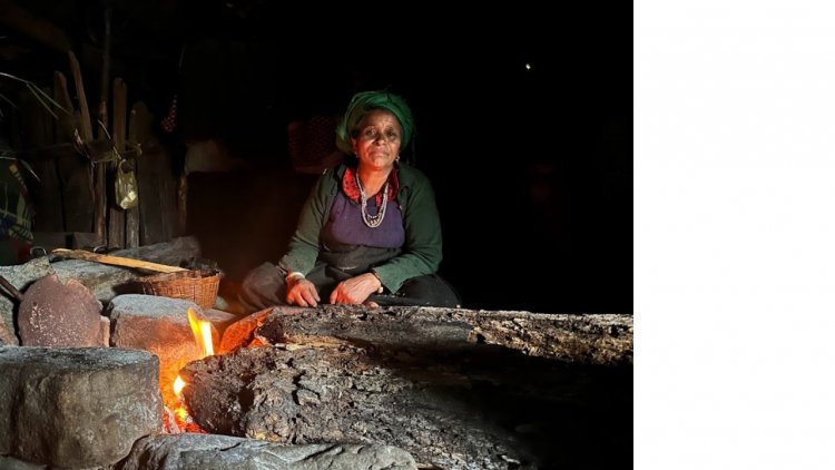
A stroll along the bylanes gave an insight into the busy life of men, women, and children at school, infants frolicking around, and the daily chores of the village folk drew my attention.
What mesmerized me was just a road to connect the village after 13 years.
Rest all found to be same...
After greeting the village folk, we walked into the pine forest. Our destination for the day was Kalyani Bugyal around 8 km away. After walking 3 km, we came across a group of trekkers from Mumbai accompanied by a local guide, who were returning unsuccessful after attempting the Mayali Pass.
They mentioned heavy snowfall and deadly crevasses. They concluded that it was a nightmare !.
We bid goodbye and moved forward. We camped at Kalyani Bugyal for the night though it was raining. There was a heavy downpour that lasted for 20 hours nonstop. The local shepherd family was kind enough to host us and offered us yummy buttermilk.
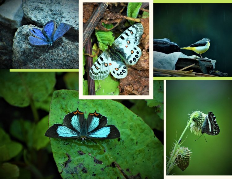
Unmindful of the drizzle we were engaged in watching a yellow wagtail and butterflies Mountain Apollo, Common Marmon, Striped Winged Skipper, Green Sapphire, Evil eye butterfly, and Painted Lady, fluttering around.
Day 03 Kalyani to Kharsoli Altitude 3645 m
Unmindful of the drizzle we moved on, armed with rain gear. The distance was 10 km.A mixture of forest paths, landslides.and river for the company.
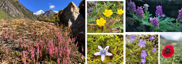
it was flowering season and the trail was a riot of colors, with blooms of Potentillas, Aster, Erigerons, Primulas, Anemones, Daisies, and Bistorta dotting the valley.
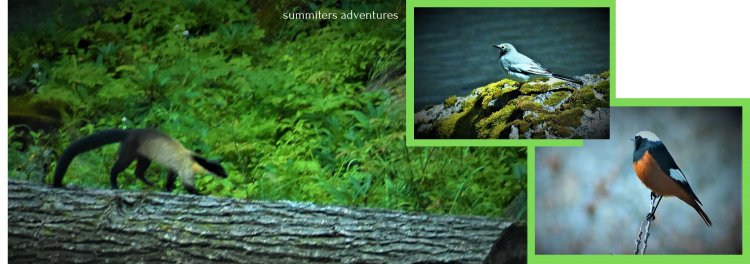
We walked parallel to the roaring river, the landslide route slowed our pace. We were fortunate to watch white-capped red start literally following us. We even were blessed to get a glimpse and watch 2 pairs of Yellow-throated Marten playing gracefully on the other bank. Our guide told, us that very few hikers pass this route and there is a huge opportunity to behold and sight wildlife on the trail. He even mentioned a few instances of sighting brown bears on the trail.

We reached the campsite next to a rivulet by 2 p.m. overlooking the mountains. It was sunny, a great opportunity to sun dry the damp clothes and tent. We witnessed a colorful sunset in the evening from our campsite which served as a vantage point.
After a quick dinner by a campfire, we rolled into our sleeping bags as darkness fell and gazed at the star-studded sky!
Day 04 Kharsoli to Tambakund
The hike passed through pine and birch forests. We could see a variety of birdlife along the trail. Team members Ananth and Vinay mentioned of the grunting sound of bears from the hilly slope. Later we came to know that the region has stone caves and a breeding season for mountain bears.
Our campsite was next to the trail, though not so impressive, but had a view of valley and mountain peaks from here.
Day 05 Tambakund to Bugdiyaar Campsite
We were covered by high mountains and getting the warmth of morning was something pleasing. We left the campsite around 7 a.m. after breakfast with a packed lunch. The shepherds who had moved downward, cautioned about the makeshift bridge and crossing of the river.
During a landslide crossover, one of the members Vageesh, sprained his leg during a descent on the rock face. Though recovering from viral fever, did not lose his morale, but kept moving after first aid.
After about 3 hours of trek along the river on the left bank, we reached the end of the valley. We could witness the wooden bridge intact and in a condition for crossover to the other side. Our guide Lakpath analysed the condition and we one by one cautiously crossed the bridge on all four. The river was flowing with heavy currents and we thanked the shepherds, for keeping twings intact!
Note
We crossed the flowing river Bhilangana using safety gear. Do not forget to carry proper rope anchors and use the belay technique. A small imbalance or mistake can lead to a mishap.
You may be carried away in the flowing river without mercy!
As we hit the high meadows and confluence of the Doodh Ganga and Bhilangana rivers, we could feel the altitude change. I was mesmerized to see mountain peaks mirrored in the shallow pond. The sound of the stream, mist enveloping the valley, and view of Gangotri I ( 6672 m ) and Thalaysagar Peak ( 6904 m ) in the Gangotri valley.
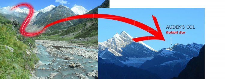
I could see the ice fall and reminded me of my 2011 Audens Col Expedition, arriving successfully at Chowki after successfully crossing the pass.. We stopped at Simli, a campsite adjacent to Chowki Campsite. for lunch The panoramic view from here was spellbinding!
A steep climb traversing the slopes, with the aroma of juniper which grows profusely here, made us feel like heaven!. Our campsite was on a vast grassland overlooking the valley and mountains. We watched the play of clouds and sunlight in the valley.
Day 06 Bugdiyaar to Masar Taal Campsite Altitude 4139 m
We started early around 7 a.m., as the day was long. We climbed above until we moved into the boulder zone. A good, 6-hour hike uphill brought us to the campsite on a green patch overlooking the Doodh Ganga Glacier. Our tents overlooking the valley, served as a vantage point to witness the Panorama before us!
The whole valley was studded with a variety of flowers, such as bistorta, star Swertia, violet monkshood, and Geranium in full bloom.
Impressive Jogin Peak, dominating the valley and above the Doodh Ganga glacier was a sight to behold.
We were short of 500 meters of Masar Tal and the campsite served as an ideal camping patch.
The trail too is still clean, with no trash. All members seemed to be in a good state, with no headache. Though few expressed their desire to camp closer to the lake. The guide was hesitant to do so.
However, it was a good decision because climbing up and sleeping at low altitude will help to acclimatize well.
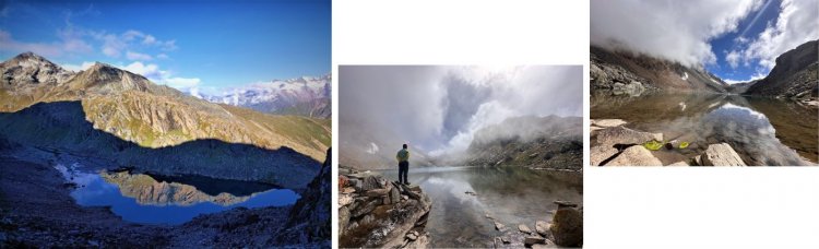
After a cup of hot coffee, we left to get a glimpse of Masar Tal. After a 15-minute walk, manoeuvering the boulders, we were face to face with a high-altitude lake, in all its glory. The rising mist, Cairns around, the play of light, still mountains, and absolute silence moved us. As a customary ritual, we prayed to the mountain gods, for a safe trip.
Listening to the sound of flowing water from the lake, we meditated for a while and experienced the silence!. It reminded one of the quotes
The beauty you see in me is a reflection of you!
- RUMI -
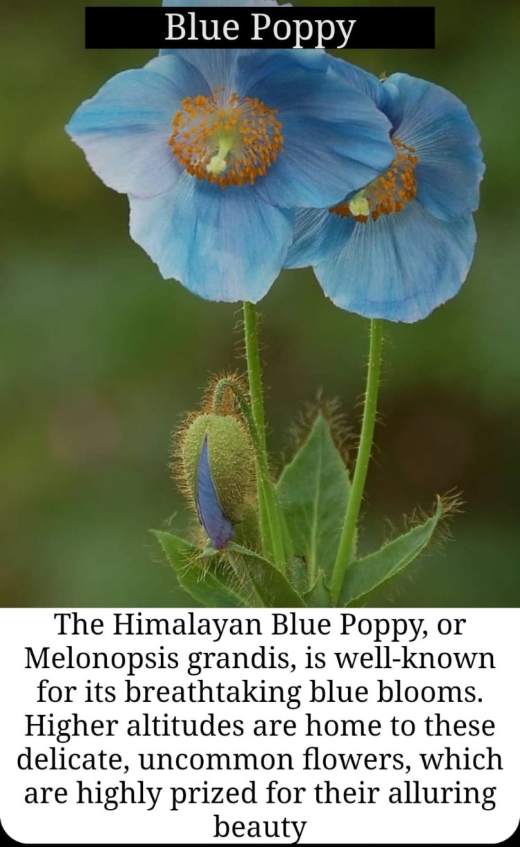
I could see, a Himalayan blue poppy peeping out and exhibiting its colors.( During my visit to Bhutan, though it is the National Flower of Bhutan and Ladakh too, I heard from my Guide that its difficult to spot on trail and has been extinct in the kingdom of Bhutan )
Brahma Kamal, Aconitum - Known as Wolf's bane, Himalayan snowberry drawing my attention from below the rocks, the whole valley seemed to be glowing in the sunlight.
Day 07 Masar Tal Campsite to Intermediate Camp Via Mayali Pass 17,400 feet
Our guide insisted on starting early. We were out of our tents and climbed the boulder zone above Masar Tal. It was a rock fall area and negotiated the rock zone slowly. It took us almost 2 hours to reach the Masar Tal Top. Though the uphill path through the boulders was a killer climb, in spite of the difficulty Vageesh never stopped or complained, but made up to the summit a little late. The view of Lake and Khatiling Peak, Icefall, Bhilangana Glacier, and Rabbit ear of Auden's col was a sight to cherish.
View from Masar Tal Top ( Reference only )
We spent almost 30 minutes clicking photographs of distant peaks, Phen Kamal, Kasturi Kamal which grew profusely here. Below us was the oblong-shaped Masar Tal Lake in a bigger version, doodh ganga glacier, below Jogin Peak. I could hear the thundering sound of falling rocks and massive icebergs floating in the lake.
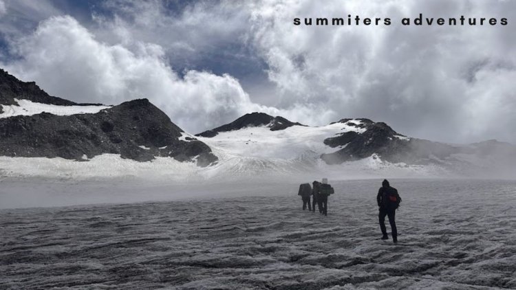
We slowly took the right bank and negotiated the moraine. It took us almost 2 hours to reach the glacier, which leads to Mayali Pass, the ' V " shaped partial view of the depression, gave a clear indication that there was fresh snow on the pass and crevices were covered by fresh snow, and it was imposing danger with hidden crevasses during climb.
Our guide along with Ananth led the team and negotiated the slopes. We came across a few hidden crevices, which are a death trap during the glacier traverse.We successfully overcame using pick axe method
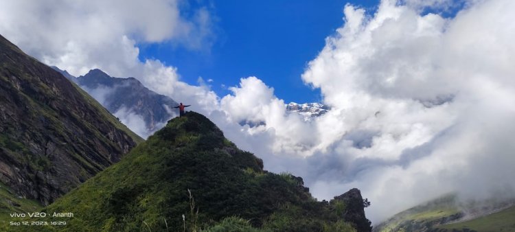
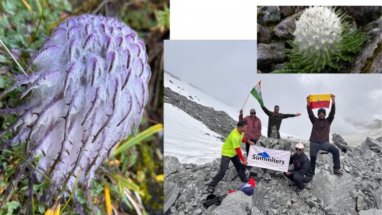
It was sunny and took us almost 3 hours to reach the Mayali Pass located at 17,400 feet. The wind was blowing, at high speed. The dark clouds loomed above on the horizon. We spotted Glacial Snow lotus, and Kasturi Kamal on the slopes.
We performed pooja, and remembered goddess Nandadevi - The bliss-giving goddess, for making us reach atop in one piece. We posed for mementos to cherish holding Flags of Tricolor, Karnataka flag, and Summiters to celebrate our achievement.
We decided to have lunch at Paiyya Tal or Phania taal which was located 800 meters below overlooking the valley. Our intention was to walk till 5 p.m. and camp at a meadow before Vasuki Tal, yet another lake below Vasuki Top.
Though we had Plan A, we had to camp before as an emergency because it began to rain with thunderstorms. It rained for almost 2 hours.
All were tired, it was cold and we were served hot soup. followed by a dinner. We slept around 6 pm.
Day 08 Trek to Kedarnath
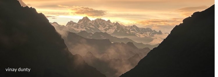
The next morning we woke to the call of Monal Pheasant, the whole valley down below was in ablaze. The snow peaks of Kedar Valley kissing the skies dominated the valley. We descended the rocky boulders. As there were NO cairn markings, we had to descend with utmost CARE. The loose rocks and the previous night's rain had made the trail slippery.
We took the right path and descended the valley until we reached the grassy patch. As we neared Vasuki Tal, the path gave way to green pastures, laden with wildflowers. The unfolding scenery made us curious every minute.
NO soul was around and the whole lake was covered in a blanket of mist!
After all members reached. We performed puja, remembering the serpent god, Lord Vasuki. Our guide began to narrate a few stories from folklore. We began to climb the rocky pinnacle, through the zig-zag path negotiating the rocky patch.
Finally, after a 2-hour climb, we reached Vasuki top, which leads to Kedar Valley.
It was tiring and cold. The path from Vasuki top forks into 2 different routes, The path to the right leads to Gaurikund and the other to Kedarnath Dham on the Left side. We took the latter one. As I descended, I could see the Chorbari Glacier, Barte Kunta Peak, Kedarnath Peak, and the peaks of Mandani Valley.
I could hear the sound of helicopters, flying to and fro commuting pilgrims. The sight of Kedarnath Shrine gave way to sheer joy and thanked the Lord for being with us at all times. The steep zig-zag path seemed never-ending until we reached the Camping ground below.
The Massive Snow-clad Peak of Sumeru, Mount Kedarnath in the backdrop looked imposing. We helped the porters to pitch the tent and decided to visit the temple as the bells rang. We returned after paying obeisance to the almighty!
It rained heavily, followed by thunderstorms and lightning all night. never before. We remembered the mountain gods again for a safe descent.
We literally felt that Trust can literally move mountains !.
What Trekkers say after successfully completing Mayali Pass Trek...
Things to consider during planning Mayali Pass Trip
1. Keep group size minimal 6 - 10 members. ( More than is a CROWD )
2. Know about members willing to join, about health, past experience of high altitude trek, weather forecast, Camping gear, Personal gear, and fitness levels.
3. Buffer of 1 - 2 days for acclimatization and emergency. The minimum number of days required for Mayali Pass Trek from Dehradun to Dehradun is 10 Days.
4. Carry sufficient ration, fuel, and gear for members/staff. Good tents 3 seasons type /Sleeping bags are a MUST.
5. Acciliitize well as Altitude can hit anyone anytime.
6. Plan with the right people who have previous experience of terrain, guiding, and logistic support.
7. Permits are mandatory. Don't forget to register before the trek.
8. Lastly follow the Leave No Trace policy and be a responsible trekker.
Please feel free to share your past experience of MAYALI PASS with us
If you are impressed and willing to do or need our assistance if any for arranging a trip. Please don't hesitate to contact us
@ +91 9740360365.
We will be happy to assist at all times. In all possible ways!